Union Falls, Old & New
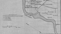 A map of Union Falls
by Jim Libby
Today, few people in Buxton, Hollis and Dayton can imagine that Union Falls, the quiet acreage surrounding the Saco River where Dayton and Buxton meet, was once an epicenter of activity in their towns. In fact, many do not know where Union Falls is located, or that a place called Union Falls even exists.
The village of “Union Falls” includes the area from the corner of the Union Falls Road and the Simpson Road in Buxton all the way down to the Saco border, just north of the historic Stackpole Creek and its stone archway. On the Dayton side, acreage includes parts of Company Road, Hollis Road, Union Falls Road, and Landing Road.
Beginning in the early and middle 1700’s, the industrious and the brave pushed into the frontier (yes, Buxton/Hollis was the frontier), coming inland from the mouth of the Saco River. Settlers came in slow increments, requiring forts to be built and garrisons maintained.
The Saco Block House was built around 1728, approximately 26 years before the fort at Pleasant Point in Buxton. Sylvester reports in Sokoki Trail that the first and second stories were equipped with cannon, “mounted to be served from the portholes in the upper story,” as preparedness was the key to survival in these years.
A few inhabitants came by the authority of the grant of land that is now Buxton to the soldiers who fought in the Narragansett War. According to Jewett and Hannaford’s History of Hollis, rights on the Hollis/Dayton side stemmed from “purchases made by Major William Phillips [from] two Indian sagamores, Hobinowil and Magg Hegon, in 1660 and 1664.” Some rights were handed down and/or sold. Far more individuals settled on “unclaimed” areas of land in Buxton, Hollis and Dayton.
Erection of the Saco Block House was the single most important element of progress that allowed Union Falls to fully develop into an industrial and residential area. The Block House was the first major fort and trading post located near Buxton and Hollis. The fort was later called the “Truck House,” as its purpose shifted toward trade and away from defense.
Access to the Block House was difficult in the 1730’s. The river was one option to transport travelers and goods. Some walked. Others rode via horseback on the “Rope Walk,” or attempted carts led by oxen through the muddy, rooted forest ways. According to The Records of the Proprietors of Narraganset Township Number One, Rope Walk was a name for the long, narrow township of Little Falls and the pathways forged on the west side of the Saco River through what is now Dayton and Hollis. For a time, eastern access to Union Falls from the Buxton side of the river was more treacherous than access from the west.
The settlement of Buxton and Hollis came nearly a full century after the successful settlement of Biddeford. This slow progression inland was emblematic of the difficulties of living away from the coast during those early years. The necessity of some men to serve in King George’s War in the 1740’s also delayed permanent settlement of the area.
Sylvester best explains the general living conditions of the early to mid-1700’s:
|
|
“These were the days of temporary dwellings. They were thrown together at haphazard, covered with bark, for their builders knew not when the woods would echo with the whoop of the Sokoki, who left always a trail of smoke to indicate their passing. It was essentially a one-room cabin, scant in the necessities of living…when the old woman and her herbs were potentials; when a sip of wintergreen was always asteep on the hob and a swallow of thoroughwort was worth more to a man’s liver than the entire contents of the modern drug store.
|
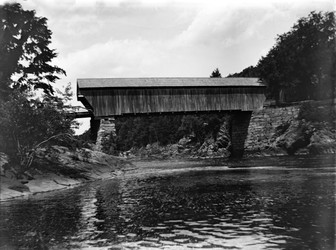 Union Falls Bridge before 1922 dam
As time passed, more families were able to stray further from the protection afforded by the garrison, but the river remained a critical resource to Union Falls. Jewett and Hannaford write about early complaints that the netting of salmon and other fish species near Biddeford was preventing fish migration. From fish runs to log runs to the development of power for the mills, the mighty Saco was central to the way of life. With the eventual establishment of a grist mill, sawmills, tanneries, and farms, employment in Union Falls surged through the 1760’s and 1770’s, particularly on the Hollis side of the river.
According to The Records of the Proprietors of Narraganset Township, No. 1, now Buxton, Maine, Union Falls gained its name from “the fact that the first mill-builders and owners – the Dunns, Gordons, & Haleys – were all united partners in business.” Some doubt this account, but it is the best documented explanation for the village’s name. At times in the early 1800’s, Union Falls was also referred to as Hopkinson's Mills, after Stephen Hopkinson, an important investor, mill owner, and public figure.
During the early 1800’s, Union Falls expanded at a brisk pace on both the western and eastern shore, as well as on roads leading away from the river. When the freshet of 1837 wiped out many of the mills and buildings nearest to the river, reconstruction came quickly. Cousins and Hannaford’s describe the scene in 1845 in “Recollections of Old Buxton, Maine”:
|
|
[There was] “A double sawmill, double whipper mill, grocery store owned by Thomas Carll...a blacksmith shop [and] a shoeshop owned by Fenderson.” “On the south bank was a Grist Mill; farther down, a tannery; a shop where coffins were made; and a boat yard run by Shorey where vessels (for river use, probably) were made. A mill which made clapboards and shingles was located at the foot of the falls.
|
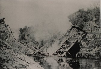 Demolition of the old Union Falls Bridge
For a time, Union Falls had its own store and post office, operated at its end by Jesse Harmon.
Thus, from 1760 to 1850, Union Falls was the economic hub for the citizens of Buxton, Hollis, and Dayton. The last store, located near the west entrance of old covered bridge, was sold around 1890, as activity had moved to Salmon Falls, the Barr (Bar Mills), Moderation (West Buxton), and beyond.
The scene on the right depicts the demolition of the old Union Falls Bridge on November 3rd, 1921. The economy that once thrived in Union Falls had long-since faded. This was the last covered bridge completely within the boundaries of York County (the Porter-Parsonsfield covered bridge between Oxford and York County still remains today).
A few residences from the era remain on both the Buxton and the Hollis/Dayton side of the river. Old logging roads and dirt ways that were once town roads can still be traversed. A walk along the shore or a trip in your canoe below the Skelton Dam will reveal the old bridge abutment. A ride in your vehicle will still display the lovely old brick and stick-built homes of the past. Your off-road bicycle trip should include the graveled part of the Dennett Farm Road in Buxton, all the way down to a turnaround located on a bend of the Saco. A walk through the woods will even yield an abandoned home, piles of bricks and granite, and some of the eeriest graveyards you’ll ever see, smack dab in the middle of the woods. It is a peaceful place - a place of the past. Union Falls, Maine.
**We are delighted that Jim Libby agreed to write about Union Falls for this issue of the newsletter. A faculty member from Thomas College and a visiting professor at Colby College, Jim has had a distinguished career as an educator, an author, and a politician; all of these vocations are encompassed in this brief history of Union Falls. He also is an expert at the sport of basketball! Jim has written four books to date. Two of these are available for purchase at the BHHS gifts hop: Buxton: A Postcard History and Took Three Lives, a century-old story of a murder in a "haunted house" in Standish. This article was written in collaboration with Meg Gardner.
